Glacier National Park – Sculpted By Ice

Montana, Glacier National Park, waterfalls

Arrowhead Fal

We settled in for a long drive of about six hours from east of Butte, Montana to Big Creek Campground in the Flathead National Forest near the west entrance to Glacier National Park. Montana is a big state and distances on a map can be very deceiving. We chose to stay at the National Forest rather than at a campground in the park as we are on the upper limit for the park campgrounds. After looking at the sites later we were very glad we made that decision. Our site at Big Creek was large, wooded, private and offered lots of free firewood. The only downside was a two mile stretch of very rough road. Later we found another way in that while longer only had a short stretch of rough road. We are still dry camping but came in with a full tank of water. Good thing as the water connection was a long way from the trailer. The campground is along Big Creek, a major tributary of the Flathead River. The Flathead is a National Wild and Scenic River. The whole area is a fisherman’s and rafter’s dream.

Glacier National Park, Going-To-The -Sun Road

Along The Going-To-The-Sun Road

Glacier NP is half of what is called the Glacier-Waterton International Peace Park. This is the only park in the world dedicated to long standing peace between two countries. We didn’t get to Waterton this time but “when we come back… Glacier NP has been on my bucket list longer than I care to admit. I wasn’t disappointed. While I haven’t been to Machu Pichu (not yet anyway!) this is what I imagine it will look like. At over a million acres this is a huge park. There is only one road running through the park from east to west, The Going-To-The-Sun Road. It is 50 miles of the most gorgeous scenery we’ve seen since the Beartooth Highway. Completed in 1932 it is considered an engineering marvel and is a Civil Engineering National Landmark. On average it opens about mid June and is passable until mid or late September. This year it had opened only to be closed again by 2′ of snow, the same snow storm on June 17 that gave us a dusting at Red Rock Lakes NWR. The park averages 25′ of snow a year so plowing the GTTS is difficult and dangerous. Just east of the high point at Logan Pass drifts can be 80′ deep!

The drive , if you don’t stop, would take about an hour and a half. So for us, it was an all day trip on day one and about 3 hours on subsequent drives. From an area called The Loop to Rising Sun the road is cut into overhanging rock on one side and a low (18″) guardrail overlooking a steep (1,000-2,000′) valley on the other. I felt so small and insignificant in this vast wilderness. So you tend to crowd the middle line. We didn’t think about pulling in our mirrors and there was no warning sign. On the way back to camp we clipped mirrors with another truck and the driver’s side mirror shattered. From then on we pulled mirrors in! A bit like closing the barn door after the horse is out! Fortunately we were able to get repairs made in Whitefish about 20 miles away.

forest fire, black and white photography, Glacier NP

Silent Sentinels From Fires In 2003

wildflowers

Fireweed In Bloom


glaciers, lakes, Montana

Glacier Blue

mountain stream, photography

Soft Water


wildflowers

Late Summer Wildflowers At Glacier


Black Bear

Our Only Bear

View Looking Up Lunch Creek

View Looking Up Lunch Creek

We’d expected gorgeous scenery but we weren’t expecting so many fabulous waterfalls. Lunch Creek is a favorite stopping spot both for a hike uphill to the falls and for sitting, wading and picnicking. Day two we had planned to take a boat ride on St. Mary’s Lake to other falls and go on a Ranger led hike. I say planned because after we got there and got unpacked, Steve couldn’t find the car keys. He tore the truck apart. Realizing we were not going to make the trip today, I changed reservations to the next day. He was going crazy and still not finding the keys when I returned. I started looking too. I went through my purse and…you guessed it, there they were. I don’t remember picking them up but obviously I did thinking they were my set. You know your husband loves you if ……. I do love her EVEN when she does things like this!

waterfalls

Swiftcurrent Falls

So what to do the rest of the day? We drove over to another area that is not on the GTTS Road called Many Glacier. Glacier NP is not named for the glaciers that used to be there but for the action of the glaciers on the landscape. As of now, it is expected that all of the glaciers will have melted by 2030. A glacier by definition must be 25 acres in area, 100 feet deep and be moving. We spent time along rushing streams, took photos along Swiftcurrent Creek and walked part of the Ptarmigan Trail. We’d started too late to get all the way to Iceberg Lake but met several people who were on their way back. All said it was well worth the hike. Another thing for when we come back. By the time we got to the truck it was dinner time and we still had a two hour drive back. It was getting dark and rainy. So we grabbed pizza to go and took the “long” way around rather than drive the GTTS in the dark and fog. We kept saying “bet this is beautiful if we could see it!” Opal was very glad to see us after 12 hours in the trailer. They keep telling me how beautiful it is but all I see is the inside of the trailer.”

Scenery In Many Glacier Area

Scenery In Many Glacier Area

Steve On The Ptarmigan Trail

Steve On The Ptarmigan Trail


Glacier National Park, photography

Against The Wind

We made the drive back to St. Mary’s Lake on Friday and took the 2pm boat trip. A ranger was on board and explained a lot of park history. We especially liked learning about the early period when the railroad had built an exclusive resort on the lake.  We cruised by Little Goose Island. There is an overlook for the island on the GTTS that is the most photographed place in Glacier NP. We tried to get sunset pictures after the cruise but Mother Nature only gave us thick clouds and no sun. After docking we took a 3 mile hike to two waterfalls; Barring Falls and St. Mary’s Falls. The scenery from the trail was spectacular! On the ride back we saw Triple Divide Peak. This is only one of two places in North America where water flows in three directions: to the Mississippi on the east, to the Pacific via the Columbia River on the west and to Hudson’s Bay to the north.

boat, St. Mary's Lake

Cruise Aboard The Little Chief

cruise, St. Mary's Lake

Beautiful Day On The Water


Barring Falls

Barring Falls

waterfall

St. Mary’s Falls


Glacier NP, boat ride, St. Mary's Lake

Approaching Little Goose Island

Ranger Talks About Medicinal Use Of Plants

Ranger Talks About Medicinal Use Of Plants


triple divide

Triple Divide Peak


hike

View From Waterfall Hike


We finally got to Logan Pass for the much heralded hike to Hidden Lake. Believe them when they say that the parking lot fills early. When we arrived at 9:45 we got one of the last parking spots. After that, getting a spot is like going to the mall the week before Christmas. Logan Pass is the highest point on the GTTs road. If you do no other hike, plan on this one. It’s about 3 miles to the Hidden Lake Overlook and 7 to the lake roundtrip. The scenery, the wildflowers and most of all the symbol of Glacier itself, the mountain goats make it very special. I only wish the guy that made the boardwalk had thought about people with short legs when he built the steps! At about 8,000 feet it was much colder. I was glad I had a pair of fingerless mittens in my camera bag.  Just when we reached Hidden Lake a few raindrops fell. We didn’t stay long as we could see the storm coming. About halfway down it really began raining and sleeting. Sleet doesn’t feel good on a bald head! Steve cut a black plastic trash bag and slid it over himself and his camera. Fine except that it was so tight he couldn’t move his arms. If he’d fallen he’d probably kept bouncing all the way to the bottom! My jacket was water resistant but by the time I got to the Visitor Center I was soaked through to the skin and very, very cold. I made a quick stop at the bathroom and when I came out the sun was shinning. People just arriving looked at me like I’d just gone overboard and been rescued. It was a long, cold ride back to the trailer.

Logan Pass, wildflowers

Wildflowers At Logan Pass


hiking, Glacier NP, landscape

Hiking To Hidden Lake


mountain goat

Ahhhhhhh!!


Columbian ground squirrel, wildlife, Montana

Time For A Snack

nature, mountain goats, Logan Pass

Three Mountain Goats Along A stream

hike, Logan Pass, Hidden Lake

Hidden Lake Overlook

We’d hoped to do some kayaking but by the time we finished sightseeing and hiking the weather had become overcast and rainy with a “winter comes early” feel to the air. Guess we will just have to come back! We did drive up to one of the smaller lakes on the west side called Bowman Lake. The access is good until you start up toward the campground. This is suitable only for tents and truck campers. A rough, narrow dirt road but worth the effort as the lake is gorgeous. The rocks just below the water at the lake’s edge have so many colors. On the way back we stopped at the Polebridge Mercantile, a general store/bakery. We loaded up with cinnamon huckleberry bread (made great french toast), huckleberry bear claws and eclairs. Polebridge was one of the first commercial enterprises near Glacier NP. It still has cabins and a bar/restaurant with local musicians. A few buildings are from the original homestead.

Bowman Lake, Glacier NP

Bowman Lake

Color Under The Surface

Color Under The Surface


Delicious Bakery!

Delicious Bakery!


These pictures barely do this park justice. You really need to come see for yourself. Have we just found a new favorite national park?

Rain, Rain … Go Away

Next stop: Butte and Helena area of Montana. We’d put off getting the RV window replaced for 4 months due to the long dirt road out of the refuge. We didn’t want to pull the trailer on it more than necessary. Rocky Mountain RV is a Dutchmen RV dealer so we’d contacted them about the work. It was an easy repair for them and we picked up the trailer by that evening. We weren’t supposed to drive at highway speeds for 24 hours until the caulking dried. So we did our first Wal-Mart night about a mile down the road. Since this store is just off I-90, it is a very popular overnight spot. There must have been 15 RVs there.

Jefferson River, Montana

View Of Jefferson River Valley From Lewis And Clark Caverns

We arrived at Lewis and Clark Caverns about 25 miles east of Butte the next day on a sunny afternoon. Less than two hours after setting up the trailer and screen house we were hit by a horrible thunderstorm that almost swept away the screen house but for the fact that Steve was outside when it hit. He dove for some shelter and was able to hang onto the tent. Down came the tent, never to be put back up. The next four days were heavy rain to drizzle and cloudy. Every local we met commented “This never happens in August! This is our driest, hottest month. We’re usually worried about fires not floods.” Four inches of rain later the sun came out. So most of our activities were inside. Most of the Montana State Parks are dry camping with water available. This park did have pay showers. By now we have a good routine for life without hookups.

Montana, Lewis and Clark Caverns, cave

Formations At Lewis And Clark Caverns

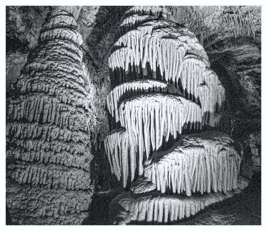
After spending a lazy morning inside safe from cold and rain (My heart went out to the tent campers) we took advantage of a “dry” period to tour the caverns. The caverns were discovered by local cowboys in the 1880s and they enlisted the aid of another local by the name of Morrison to explore them. Morrison had experience with mine tunnels and a construction crew. Sensing an opportunity, Morrison began to give tours. The railroad was legal owner of the mountain and put a locked gate across Morrison’s new entrance. Morrison just came back with bolt cutters. This seesaw activity  continued until his death in 1932. Most of the damage in the caverns occurred at this time when visitors were encouraged to take home samples. The railroad turned the caverns over to the National Park Service and for a time it was a National Monument under the management of Yellowstone NP. Why is it not still a National Monument? Travel to Yellowstone was difficult enough much less adding another  four days travel roundtrip, an uphill climb with a 1700′ elevation gain and 2000 rickety wooden steps to be climbed up and down. With minimal visitation the federal government turned the caverns over to the state with the provision that safer, easier access be made. The CCC built 500 concrete steps going down, 100 coming up, a new exit tunnel, handrails and better lighting all with hand tools and minimal blasting. Today you access the entrance along a 3/4 mile paved path and steps with a 300′ elevation gain. The caverns are accessible only on a guided tour for $10/person. While we’ve been in several caves and caverns this one did have great variety. Our guide, Holly, did an excellent job of sharing information and entertaining stories. One thing we’d never done before is enter one chamber by sliding on our fannies. Lewis and Clark Caverns is Montana’s first and largest state park. While we were there they celebrated 77 years of operation.

Lewis and Clark Caverns, state park, tour

Drapery Formations

Santa, cave, stalagtite

Santa Is A Stalgtite

cave formations, photography

Formations In Black And White

mine tour, Butte, Montana

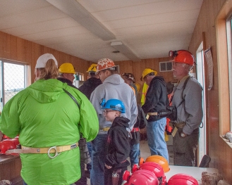
Donning Hard Hats And Lamps

More rain the next day so we went underground again. Not back to the caverns but to the World of Mining Museum in Butte. Butte began as a gold rush town in the 1860s. This was followed by silver mining and finally by it’s claim to fame…copper mining. Even after almost 100 years of copper mining it is said that more copper lies underneath Butte than has been removed. Butte is sometimes referred to as the city that’s a mile high and a mile deep. Underground mining was replaced after WWII by open pit mining (The Berkley Pit). Because water mixing with copper slag made highly acidic water (Ph 2) the site has been one of the most extensive Superfund cleanup locations and will be continuing for decades. The largest, The Anaconda Company, stopped production in the 1970s. Butte’s economy was dealt a lethal blow. Slowly the city has recovered but mining remains a vital part of it’s heritage.

A Mile High And A Mile Deep

A Mile High And A Mile Deep

working in the mines

Backbreaking Work

mules, mines, old photo

Getting The Mules Down To The Mines


mine worker

Ore Bucket With “Dugan”


The World of Mining Museum is a must see if you are in the area. We loved the old photos and sketches displayed at the museum. Do take the underground tour. Our guide had been an electrician in the mines so Steve asked him several questions about his work. We learned a lot of interesting facts such as the nickname for the large ore rocks in the buckets. They were called “Dugans” because the carts could become top heavy, topple and crush the miners. Why “Dugans? That was the name of the local funeral home! In 1917 there was one of the worst mining disasters in the country when fire broke out underground and 168 men perished. This led to many of the safety measures that are in place today and the formation of the Mineworkers Union. From 1914-1921 Butte was under military rule due to the miners unrest. We were surprised to learn that the general in charge was none other than Omar Bradley.

mule skinner, sketch

Mule Skinner Riding The Ore Carts

mine bike

Supervisors Mine Bike

mining town

Recreated Mine Town Street

church, mine town, Montana

Old Log Church

Steve At The Kraut Factory

Steve At The Kraut Factory

A self-guided surface tour through exhibits and a reconstructed mine town shows all the services that sprung up around the mines. Most of the miners were of German, Irish and eastern European ancestry so some of the businesses such as the sauerkraut factory reflected this. It took three people on the surface to supply services for every every miner underground. This was the first time we had seen the Chinese immigrants (laundry, herbal medicine) in business. If you go we hope time will allow you to see the 90 minute film Butte: An Original which was made for PBS. It covers mining but goes into the post 1970 period showing evolution from a company town to modern city. While we didn’t get to take the tour to Our Lady of the Rockies because of bad weather the film shows how it was constructed using a helicopter crane. I won’t give away one heart stopping scene. You’ll just have to go see for yourself. Butte has one of the largest historical districts in the nation and is home to the Montana Music Festival, just two reasons for us to return.

prison, Deerlodge, Montana

Inmates Constructing Prison c. 1885

Day three…more rain. We found yet another inside activity, The Old Montana State Prison and the Montana Auto Museum in Deer Lodge. The prison is a looming granite structure built mostly with inmate labor and gave a grim look into life behind bars during the first half of the 20th century. A new prison has been built on what was once the prison ranch land about 5 miles away. Of note were two uprisings that ended in the death of a prison official. One uprising was ended by Bazooka fire from the National Guard and the damage to the building can still be seen.

Makes The RV Look Big

Makes The RV Look Big

old Montana prison museum

Damage From Bazooka During Prison Riot

In the same building is the Montana Auto Museum with over 200 classic autos. Some of our favorites were an old woody, an early  popup camper, a 1950s Pontiac like my folks owned and a 1959 Ford Fairlane that was my first car. It took me a long time to save $200 for it!

old cars

Cars From The 40s

Fab Fins Of The 50s

Fab Fins Of The 50s

old RV

This Cost $200 in 1920


This 1951 Pontiac Sure Brings Back Memories

This 1951 Pontiac Sure Brings Back Memories

Without a doubt the most unusual car was the modified VW Beetle that was used in Mad Max- The Road Warrior. Later it was bought by a retired Colonel who had great fun attaching other mock weapons until he was stopped one day by the Wyoming State Police and asked to remove the machine gun. Their switchboard had been flooded with calls about it!

cars

Move Over Hummer!

Grant-Kohrs Ranch NHS Panorama

Grant-Kohrs Ranch NHS Panorama

Day four… drizzle in the morning but finally…SUN!! We returned to Deerlodge to visit our 107th National park site, the Grant-Kohrs NHS. If you are a fan of miniseries like Centennial or Lonesome Dove then you would see those stories come to life here. The ranch demonstrates cowboy life on a cattle ranch and the role ranching played in the settlement of the west. Most of the buildings are open for a self guided tour but the home can be viewed by guided tour only. No photos are allowed inside of the house. Most of the furnishings and decor items are original to the Kohrs family. The Kohrs were millionaires in their day. They not only survived the winter of 1886 when 60% of the cattle in Montana succumbed but regained all of their loses within three years. We were sorry to learn that we wouldn’t be local for the Annual Draft Horse Competition in mid-September. OK, another one for “When we come back…” We struck up a conversation with one of the volunteers. She and her husband have just begun volunteering and are trying to decide whether to sell their home and go full timing. It looks like they may be overlapping with us at Petrified Forest NP.

cattle drive, cowboy, ranch

Cattle Drive In The 1880s

chuck wagon

Replica Of A Chuck Wagon


bunkhouse

The Original Bunk House


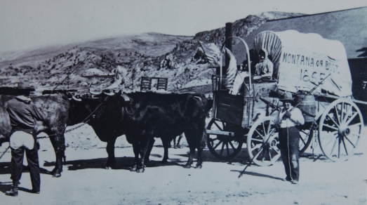
Old Photo Of Montana Homesteaders

Old Photo Of Montana Homesteaders

horses, draft horses

Draft Horses At Work


Grant-Kohrs Ranch NHS

Grant-Kohrs Homestead

As we pull up stakes and head for Glacier NP, we notice that our blog has reached over 20,000 views in a bit over 2 years. Thanks to everyone who has enjoyed traveling with us.

Roadside Trivia #10

Sorry that we’ve not been posting much recently but we were dry camping for the last 18 days. During most of that we were in poor cell signal areas which for us means no internet. Plus we were out and about seeing some great places in Montana. So while we attempt to catch up, here are a few fun facts from our recent stops.

1) What did car giant David Dunbar Buick invent before getting into the automobile industry? Hint: it is something you probably have in your house today.

2) Cows have a terrific sense of smell. How far away can they detect water?

a) 2 miles  b) 3.5 miles  c) 6 miles  d) 10 miles

3) In 1918 what US state created the system for route numbering (now used internationally) that we use today?

a) New York  b) Wisconsin  c) Texas  d) California

4) What 2 foods you probably have eaten are made from cow hooves?

Are you ready for the answers?

?

?

?

?

Mmmmmm… maybe a little anticipation to build the drama!

?

?

?

?

Stop begging!

?

?

?

?

OK, OK!!

1) David Dunbar Buick invented the process for adhering porcelain to cast iron and gave the world the white bathtub.

trivia, travel, cars

Roadside Trivia #10
Question 1

2) Correct answer is c) 6 miles

cows, sense of smell, Montana

Roadside Trivia #10
Question 2

3) Correct answer is b) Wisconsin

Wisconsin, trivia, route numbers

Roadside Trivia #10
Question 3

4) Remember Bill Cosby and J-E-L-L-O? Also Gummy Bears!

collagen, jello, gummy bears

Roadside Trivia #10
Question 4